Saturday, September 22, 2018

Hetch Hetchy Reservoir - Tuolumne County, California


Visited on 9/21/2018, Jeff and I loaded up our dogs, Summer and Skye for a day adventure to the back country of Yosemite National Park.  We visited three lakes, two actually located within the National Park boundary and one in the adjacent Stanislaus National Forest of Northern California.  Hetch Hetchy was our first stop.  Just inside the Yosemite National Park boundary on the northwestern corner of the Park lies the beautiful and scenic Hetch Hetchy Reservoir.  The reservoir is located at 3,783 feet above sea level and is 1,200 acres in size and has a depth of 1,800 feet.  Hetch Hetchy is actually the name of a valley, a reservoir and a water system in California. The glacial Hetch Hetchy Valley lies in the northwestern part of Yosemite National Park and is drained by the Tuolumne River. For thousands of years before the arrival of settlers from the United States in the 1850s, the valley was inhabited by Native Americans who practiced subsistence hunting-gathering. During the late 19th century, the valley was renowned for its natural beauty – often compared to that of Yosemite Valley – but also targeted for the development of water supply for irrigation and municipal interests. John Muir, the founder and first President of the Sierra Club fought long and hard to keep this valley from being flooded, but ultimately lost the battle because of water demands for a growing City of San Francisco and the bay area.

In 1923, the O'Shaughnessy Dam was completed on the Tuolumne River, flooding the entire valley under the Hetch Hetchy Reservoir. The dam and reservoir are the centerpiece of the Hetch Hetchy Project, which in 1934 began to deliver water 167 miles west to San Francisco and its client municipalities in the greater San Francisco Bay Area.


Cherry Lake - Toulumne County, California


Visited on 9/21/2018, Jeff and I loaded up our dogs, Summer and Skye for a day adventure to the back country of Yosemite National Park.  We visited three lakes, two actually located within the National Park boundary and one in the adjacent Stanislaus National Forest of Northern California.  Cherry Lake is located just outside the Yosemite National Park boundary and was our second stop.  Cherry Lake (also known as Lake Lloyd) at an elevation of 4,660 feet above sea level, is an artificial lake in the Stanislaus National Forest of Tuolumne County, California, about 25 miles east of the city of Sonora. It is at an elevation of 4,700 feet on the western side of the Sierra Nevada, and lies just outside the western boundary of Yosemite National Park. The lake has a surface size of 1,535 acres and is formed by Cherry Valley Dam on Cherry Creek.

The East and West forks of Cherry Creek combine just a couple of miles before reaching the lake, while the North Fork joins the East Fork about 10 miles earlier. All three forks begin in the Emigrant Wilderness and all of them flow roughly southwest. The North Fork's source is Emigrant Lake, which is at an elevation of 8,800 feet. The East Fork's source is a couple of miles southwest of the Mono County line and flows into Huckleberry Lake several miles later. The East and North forks meet several miles downstream of the lake. There are no lakes on the West Fork. Eleanor Creek, which forms Lake Eleanor, flows into Cherry Creek several miles downstream from Cherry Valley Dam. Lake Eleanor is another Hetch Hetchy Project facility. Cherry Creek flows into the Tuolumne River several miles later.
The dam is composed of earth and rock-fill and has a height of 315 feet above the original streambed. It was built by San Francisco City and County and the Modesto Irrigation District and Turlock Irrigation District.  It was completed in 1956. The lake stores water for the Hetch Hetchy Project, which supplies drinking water to the San Francisco Bay Area, Modesto and Turlock districts. Recreation available at the lake includes, boating, skiing, swimming and fishing. Human contact with the water is allowed because the water has to be filtered anyway. Water from the lake powers the Dion R. Holm Power Plant, a 165 MW hydroelectric facility.


Lake Eleanor - Tuolumne County, California


Visited on 9/21/2018, Jeff and I loaded up our dogs, Summer and Skye for a day adventure to the back country of Yosemite National Park.  We visited three lakes, two actually located within the National Park boundary and one in the adjacent Stanislaus National Forest of Northern California.  Lake Eleanor is located just inside the Yosemite National Park boundary and was our third stop.  We were able to drive across the Cherry Lake Dam and proceed about 2 miles on a rough gravel road to the trailhead for Lake Eleanor, then we had to hike about a 1/2 mile to get a view of the lake.  Lake Eleanor is a reservoir located in the northwestern backcountry of Yosemite National Park at an altitude of 4,657 feet with a surface area of 953 acres.
The lake was formed in 1918 by damming Eleanor Creek as part of the Hetch Hetchy Reservoir system, constructed to supply water and power to the city of San Francisco. The original smaller, natural lake was also named "Eleanor" after the daughter of Josiah Whitney, leader of the California Geological Survey in the 1860s.

Lake Eleanor Dam stands as a concrete multiple arch dam with a height of 68 feet and a length of 1,260 feet. This first stage of the Hetch Hetchy project was built for year-round hydroelectric power generation, which was then sold to help finance construction of the larger O'Shaughnessy Dam, completed in 1923.
That dams were planned for a valley in Yosemite National Park caused significant opposition. One of the most potent opponents was the Sierra Club and its founding President, John Muir. After two vetoes by Teddy Roosevelt, on December 19, 1913, Woodrow Wilson signed the Raker Act permitting construction. It began in 1914.

The remote location dictated the use of an unusual multiple-arch structure here. It dramatically minimized the amount of concrete used in comparison with a gravity dam. Even more unusual, the concrete arches were elliptical rather than circular, the only multiple-arch dam ever built this way.  Chief designer for the San Francisco Board of Public Works Michael O'Shaughnessy, along with hydraulic structural engineer R.P. McIntosh, were primarily responsible for the design.
Still owned and operated by the city, the lake now provides opportunities for angling, hiking, and camping.


Thursday, September 20, 2018

Lower Otay Reservoir - San Diego County, California


Visited on 9/15/2018, during a visit to the San Diego area proctoring Drinking Water Operator Certification examinations after the exams I visited two lakes southeast of downtown San Diego.  Lower Otay Reservoir is a 1,110 surface acre reservoir at an elevation of 381 feet above sea level located southeast of Chula Vista, California. Lower Otay is in the rolling chaparral covered hills with 13 miles of shoreline.  It is flanked by Otay County Open Space Preserve in the San Ysidro Mountains on the east.  The reservoir is formed by impounding the waters of the Otay River, behind Savage Dam, completed in 1918, and is also the terminus for the San Diego Aqueduct, which transports imported water from the Colorado River. The dam and reservoir are owned by the City of San Diego.
In 1897, the first Lower Otay Dam was completed by the Southern California Mountain Water Company. The Lower Otay Reservoir was connected to the City of San Diego's water system in 1906 via the Bonita Pipeline.  The original dam gave way in January 1916 following heavy rains which affected most of Southern California flooding the Otay Valley with a wall of water ranging from 20 to 100 feet in height during the event, killing more than 14 people. The flood swept away entire farms and buildings, including the Montgomery residence at Fruitland near the mouth of the river, where John J. Montgomery had built his initial series of manned glider designs. The rains were ostensibly the work of the "rainmaker" Charles Hatfield, who had been hired by the City of San Diego to assist in increasing rainfall to fill nearby Morena Reservoir. He was never charged with any crimes. The dam was rebuilt in 1918 and renamed Savage Dam. The Lower Otay reservoir serves as a terminal reservoir for a significant sized watershed, imported water aqueducts and a source of local water for the Otay Drinking Water Treatment Plant. For these reasons, the reservoir intentionally operates at a higher capacity level than many of the other City reservoirs which are used primarily for storage and rely on local rain and snow runoff.

The reservoir is the home of the United States Olympic Training center for rowing sports.


Lake Wohlford - San Diego County, California


Visited on 9/14/2018, during a visit to the San Diego area proctoring Drinking Water Operator Certification examinations in the evening after the exams I explored several lakes in the area.  Lake Wohlford is a 225 acre reservoir located in the hills just north of the City of Escondido at an elevation of 1,500 feet above sea level.  In 1889, the Escondido Irrigation District was formed in order to augment local agricultural water supplies. During 1894 and 1895, the Escondido Canal was constructed to bring water from the San Luis Rey River basin and the original Lake Wohlford dam was constructed to store this supply. Due to financial difficulties, the Escondido Mutual Water Company was formed in 1904 to acquire and improve the facilities of the District. The improved Escondido Canal and enlarged Lake Wohlford thus provided the main supply to areas outside the city limits.  The original dam was built in 1895 out of rock to store water from the San Luis Rey River via the Escondido Canal, which channeled water from Lake Henshaw to Lake Wohlford.

Nearly 30 years later — after unprecedented rains in 1916 caused the lake to overflow, causing devastating floods — the dam was enlarged and reinforced. Twenty-four feet was added to its height using silt and sand, but the materials weren’t evenly mixed.
That problem became apparent in 2006, when seismic tests showed a temblor of 7.5 magnitude or greater could crumble the newer part of the dam.  Several delays due to funding has tabled the construction project and by 2022 the Project will construct an earth-core rockfill dam to replace the existing 114-year old Lake Wohlford Dam. Replacing the dam will allow the City of Escondido to increase water levels within the lake to its design capacity of 6,500 AF. In addition to addressing flood risks, this project would provide water supply, water quality, and recreational benefits associated with Lake Wohlford.


Lake Morena - San Diego County, California


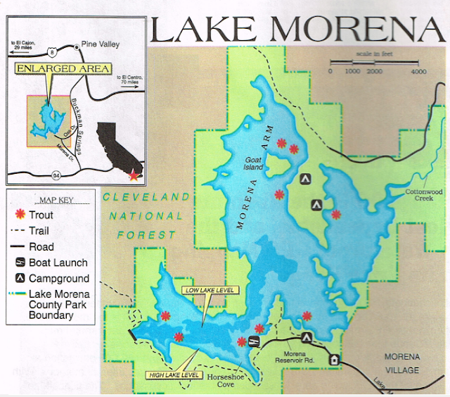
Visited on 9/13/2018, during a visit to the San Diego area proctoring Drinking Water Operator Certification examinations in the evening after the exams I explored several lakes in the area.  Lake Morena and the Lake Morena County Park is a 1,475 surface acre reservoir that is a popular camping and fishing park located in East County San Diego. Because of its location – southwest of the Laguna Mountains – the park shows characteristics of desert, coastal, and mountain habitats. Lake Morena sits at an elevation of 3,000 feet.  It is the most remote reservoir in all of San Diego County.  Lake Morena is the highest and most remote of the city's nine reservoirs. Its dam dates to the late 19th century.
When full, the lake has a depth of 157 feet.  After the drawdown, plus loss to evaporation, the lake is now at 83.6 feet.  The City of San Diego uses this as a water supply to service the water demands of the public.

On the day I visited this reservoir the Park Ranger told me that the water level was at only 6% of capacity.  Even though it is late in the season….Wow, that is really low water level.
In 1916 the city of San Diego hired Charles Hatfield, a man known as the "Rainmaker", who had offered to fill Morena Reservoir at a cost of $10,000. Although the city council doubted his ability, Hatfield was hired and set to work "rainmaking" on January 1. By January 10, flooding rains began to fall throughout San Diego County. Rising at a peak rate of two feet per hour, Morena Reservoir filled and spilled on January 26, a mere 5 inches from the top of the dam. In the rest of the county, flooding washed out bridges, inundated neighborhoods and killed over 50 people. The city subsequently deemed the rains an "act of God" and determined that if Hatfield were to collect the fee for filling Morena reservoir he would also have to pay for the damages caused by the rains. Hatfield never took the money and left town!


Lake Cuyamaca - San Diego County, California


Visited on 9/14/2018, during a visit to the San Diego area proctoring Drinking Water Operator Certification examinations in the evening after the exams I explored several lakes in the area.  About an hour's drive from San Diego, Lake Cuyamaca is a picture-book 110 acre lake that is proof positive that good things come in small packages. Situated at an elevation of 4,650 feet in an Oak and Pine forest, it is surrounded on three sides by the 26,000 acre Cuyamaca Rancho State Park, which is 52% wilderness. Lake Cuyamaca seems to be a nice getaway for folks to escape the city life for the day or several days. Few places in San Diego County offer the pristine views that greet your eyes wherever they may wander.  The dam was originally build in 1887 and thanks to a dedicated group of residents and sportsmen.  On the day I visited the water level was very low and I had to take my picture at the boat dock located right behind the popular little restaurant with the claim to fame is it makes the “Worlds famous Apple Pie”.  The lake is located about six miles south of the quaint little town of Julian, California.  Julian, California is famous for its apple pie. You can get great pie at many places in Julian. Dine overlooking beautiful Lake Cuyamaca on our comfortable deck or in the dining room.


Sweetwater Reservoir - San Diego County, California


Visited on 9/15/2018, during a visit to the San Diego area proctoring Drinking Water Operator Certification examinations after the exams I visited two lakes southeast of downtown San Diego.  Sweetwater Reservoir is a 960 acre artificial lake at an elevation of 757 feet above sea level located just east of Chula Vista, California in Bonita about 15 miles east of downtown San Diego. The lake is operated by the Sweetwater Water Authority, and allows only shore fishing on a limited 2.5 mile stretch of shoreline.  Sweetwater Reservoir is formed by the Sweetwater Dam on the Sweetwater River. Construction of the dam was completed in 1888.


Loveland Reservoir - San Diego County, California


Visited on 9/13/2018, during a visit to the San Diego area proctoring Drinking Water Operator Certification examinations in the evening after the exams I explored several lakes in the area.  Loveland Reservoir, near Alpine, is a 454 surface acre foot holding reservoir at an elevation of 1,355 feet above sea level. It’s dam is 203 feet high and 765 feet wide, and was completed in 1945. Loveland Reservoir serves as a holding area for water which is released to Sweetwater Dam. 
Loveland Lake and Dam is a true hidden gem in the backcountry about a 40 minute drive from downtown San Diego off I-8 East, just south of the City of Alpine. The trailhead can be easily missed if you blink once while driving down on Japatul Road toward the Carveacre Wind Caves and Gaskill Peak, which are the two most popular hiking trails in Alpine.
The good news about not being a popular spot is that it is almost deserted, and you can experience raw wilderness at its finest. The bad news about not being a popular spot is that… it is almost deserted — which means poor cell phone connection, light traffic on the main road and nobody to hear you screaming for help if you need to scream for help.  Although the hike down to the water doesn’t seem  very strenuous and my only vantage point to take a picture of the reservoir was from the road (ok, two miles down), but it came out pretty good from a distance.


Lake Murray - San Diego County, California


Visited on 9/13/2018, during a visit to the San Diego area proctoring Drinking Water Operator Certification examinations in the evening after the exams I explored several lakes in the area.  Lake Murray is a "in town" reservoir in La Mesa, California, operated by the City of San Diego's Public Utilities Department. It is located at 633 feet above sea level within the Mission Trails Regional Park near La Mesa. When full, the reservoir covers 171.1 surface acres, has a maximum water depth of 95 feet, and a shoreline of 3.2 miles.  The asphalt-paved service road lining roughly two-thirds of the lake's perimeter is a popular recreation site for the Navajo community. It lies south of Cowles Mountain and 10 miles northeast of San Diego’s downtown.
The reservoir was formed in 1894 with the construction of an earthen dam, and was known as La Mesa Reservoir.  In 1910 the dam and reservoir were bought by Ed Fletcher as part of his Cuyamaca Water Company. Following the great San Diego County flooding in 1916 (associated with the rainmaker Charles Hatfield), the reservoir was the principal source of water for the city of San Diego. In 1919 the dam was enlarged and the capacity of the reservoir greatly expanded. The dam and lake were renamed in 1924 after James A. Murray, one of Fletcher's investors in the water company. Fletcher sold the Cuyamaca Water Company, including Lake Murray, to the La Mesa, Lemon Grove and Spring Valley Irrigation District in 1926. The irrigation district then sold the lake to the city of San Diego in 1932.

Lake Murray is a popular site for hikers, cyclists, and runners who travel around the periphery of the lake. It is not possible to cross the dam and complete the loop like nearby Miramar Reservoir but there is 3.2 miles of path with access at multiple points.
Kayaking and catch-and-release fishing are both allowed on the reservoir. Birdwatchers enjoy visiting Lake Murray where ducks, geese, and herons abound. At least 149 bird species have been observed and recorded here.


Sunday, September 9, 2018

Eureka Lake - Plumas County, California


Visited on 9/1/2018, Jeff and I loaded up the truck camper and the kayak on the Jeep and headed up to Lake Basin Recreation Area to hike and visit several of the Lakes Basin area natural subalpine lakes.  We, of course had our water-loving chocolate Labradors, Summer and Skye with us for a wonderful weekend of camping, hiking and kayaking for my birthday.  We decided to visit the Eureka State Park and learn about the gold mining that took place in the 1850s when they struck gold up in Gold Mountain to the right in the picture.  It was a great little museum and interactive tour of the blacksmith shop, assessor's office and gold panning demonstration.  After visiting the State Park we drove up the hill about 3 miles to Eureka Lake.  This lake is 35 surface acres at an elevation of 6,120 feet above sea level.  Lots of folks swimming and playing with their children and dogs on the shoreline of this beautiful remote lake. 


Big Bear Lake - Plumas County, California


Visited on 8/30/2018, Jeff and I loaded up the truck camper and the kayak on the Jeep and headed up to Lake Basin Recreation Area to hike and visit several of the Lakes Basin area natural subalpine lakes.  We, of course had our water-loving chocolate Labradors, Summer and Skye with us for a wonderful weekend of camping, hiking and kayaking for my birthday.  We decided to take the 2.3 mile Bear Lake to Long Lake trail hike.  We visited Big Bear Lake, Little Bear Lake and Cub Lake and Long Lake.  The first lake after about 1/2 mile of hiking we came upon Big Bear Lake.  This lake is one of the smaller lake in the region at 25 acres, and is a glacial lake located in this gorgeous Lakes Basin Recreation Area. Big Bear Lake is at an elevation of 6,475 feet above sea level in the Plumas National Forest.  There are over 20 small glacial formed subalpine lakes in this area of the Sierra Mountains.  This lake was in a gorgeous setting and we hiking around to the east side of the lake for a better viewing of the entire lake.  The dogs retrieving sticks from the crystal clear waters.  We will definitely be back in this area in the future for wonderful camping adventures.


Long Lake - Plumas County, California


Visited on 8/30/2018, Jeff and I loaded up the truck camper and the kayak on the Jeep and headed up to Lake Basin Recreation Area to hike and visit several of the Lakes Basin area natural subalpine lakes.  We, of course had our water-loving chocolate Labradors, Summer and Skye with us for a wonderful weekend of camping, hiking and kayaking for my birthday.  We decided to take the 2.3 mile Bear Lake to Long Lake trail hike.  We visited Big Bear Lake, Little Bear Lake and Cub Lake.  The last and largest lake on this trail was Long Lake.  This lake is one of the larger lakes in the region at 291 acres, and is a glacial lake located in this gorgeous Lakes Basin Recreation Area. Long Lake is at an elevation of 6,680 feet above sea level in the Plumas National Forest.  There are over 20 small glacial formed subalpine lakes in this area of the Sierra Mountains.    We found a fantastic little campground with very inexpensive camp sites at only $10 per night at Goose Lake, right up against the water.  Camp spot #5 was our favorite with a fantastic view of the lake and easy access for us to kayak on the calm morning waters.  We will definitely be back in this area in the future for wonderful camping adventures.