Thursday, April 5, 2018

Ruth Lake - Trinity County, California


Visited on 3/29-4/1/2018, Jeff and I loaded up our two pups, Summer and Skye and went on a weekend camping trip in Northern California.  We found this wonderful gem in southern Trinity County half way between Eureka and Red Bluff on a very twisty with a lot of hairpin curves on Highway 36.  We were the only one camped in the campground on the first day of our trip and only three peaceful fishing boats were fishing on the lake.  This is quite a drive on a narrow road at times, but well worth the trip if you plan to stay awhile in this beautiful country.  Jeff and I totally enjoyed our two nights at Ruth Reservoir (also known as Ruth Lake).  It is the only reservoir on California's Mad River. At an elevation of 2,657 feet above sea level this 2,650 acre reservoir and adjacent community were named for early settler Ruth McKnight. Ruth Reservoir is a seven-mile long reservoir located in the southern portion of Trinity County. The reservoir was formed by the damming of the Mad River in 1962, and has served both as a functional supplier of water to Humboldt County and a recreational area for fisherman, boaters, water skiers and swimmers alike. The reservoir lies in calm, beautiful surroundings of hills covered by Ponderosa pine and white fir. The reservoir sits at an elevation which affords cool winters, warm summers, and amazing springs and falls.
The reservoir was formed by construction of R. W. Matthews Dam in 1962 primarily for domestic and industrial water supply to Arcata, Eureka, and other communities around Humboldt Bay. The reservoir was not designed for flood control storage, but limited December, 1964, flooding to 51 percent of 1955 flow at Forest Glen (on California State Route 36) and 90 percent of the 1955 flood flow at Arcata. A 2-MW hydro-electric plant with two 1-MW turbine generators is powered by water released from the reservoir. The plant generates 5 GWh during an average water year.   Dry-weather releases flow down the Mad River from the reservoir to be recovered by Humboldt Bay Municipal Water District's Ranney collectors near Essex, California. 

Visited on 3/29-4/1/2018, Jeff and I loaded up our two pups, Summer and Skye and went on a weekend camping trip in Northern California.  We found this wonderful gem in southern Trinity County half way between Eureka and Red Bluff on a very twisty with a lot of hairpin curves on Highway 36.  We were the only one camped in the campground on the first day of our trip and only three peaceful fishing boats were fishing on the lake.  This is quite a drive on a narrow road at times, but well worth the trip if you plan to stay awhile in this beautiful country.  Jeff and I totally enjoyed our two nights at Ruth Reservoir (also known as Ruth Lake).  It is the only reservoir on California's Mad River. At an elevation of 2,657 feet above sea level this 2,650 acre reservoir and adjacent community were named for early settler Ruth McKnight. Ruth Reservoir is a seven-mile long reservoir located in the southern portion of Trinity County. The reservoir was formed by the damming of the Mad River in 1962, and has served both as a functional supplier of water to Humboldt County and a recreational area for fisherman, boaters, water skiers and swimmers alike. The reservoir lies in calm, beautiful surroundings of hills covered by Ponderosa pine and white fir. The reservoir sits at an elevation which affords cool winters, warm summers, and amazing springs and falls.
The reservoir was formed by construction of R. W. Matthews Dam in 1962 primarily for domestic and industrial water supply to Arcata, Eureka, and other communities around Humboldt Bay. The reservoir was not designed for flood control storage, but limited December, 1964, flooding to 51 percent of 1955 flow at Forest Glen (on California State Route 36) and 90 percent of the 1955 flood flow at Arcata. A 2-MW hydro-electric plant with two 1-MW turbine generators is powered by water released from the reservoir. The plant generates 5 GWh during an average water year.   Dry-weather releases flow down the Mad River from the reservoir to be recovered by Humboldt Bay Municipal Water District's Ranney collectors near Essex, California. 

Since we were the only ones camping at the Lake we had our choice of over 90 camping spots we selected Camping Spot #9 right on the Lake.  It was peaceful and an awesome space right on the Lake for two nights.

 
This was campground spot #9 at the Ruth Recreational Area Campground, located right on the lake with plenty of firewood for Jeff to make his yummy fire grilled steaks and the dogs enjoyed just jumping in the lake just for fun!  It was a very peaceful and an awesome space for two spectacular nights in Trinity County.
 

Lake Sonoma - Sonoma County, California


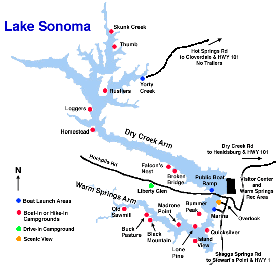
Visited on 4/1/2018, Jeff and I loaded up our two pups, Summer and Skye and went on a weekend camping trip in Northern California.  We traveled to Lake Sonoma, which is a beautiful reservoir west of Healdsburg in northern Sonoma County, California, created by the construction of Warm Springs Dam. Access from U.S. Route 101 is by way of Dry Creek Road from Healdsburg.  When we arrived we witnessed a large bald eagle nesting in the tree top at the dam vista lookout area.

The lake located at 495 feet above sea level, provides water for countywide growth and development, and for recreation. At full capacity, it has 50 miles of shoreline, a surface area of more than 2,700 acres of water.   
The US Army Corps of Engineers built Warm Springs Dam across Dry Creek. Completed in 1982, this rolled-earth embankment dam is 319 feet high, 3,000 feet long, and 30 feet wide at the top.  The dam aids in flood control, and a hydroelectric plant produces electricity from the water released downstream. A minimum amount of flow must be maintained in Dry Creek to allow fish migration.
Pomo people had lived in the Dry Creek area since at least the 18th century, and some of them resisted the creation of the lake. Archaeologists at Sonoma State University have written about the prehistory and history of Warm Springs Dam, Lake Sonoma, and the Dry Creek Valley.
 
View of the lake from the campground on the top of the hill.

Benbow Lake - Humboldt County, California


Visited on 4/1/2018, Jeff and I loaded up our two pups, Summer and Skye and went on a weekend camping trip in Northern California.  We stopped at Benbow Lake which is located at 364 feet above sea level in Humboldt County within the giant redwood tree country, just 2 miles south of Garberville on U.S. Route 101.  This 230 acre Lake is created every summer by damming the Eel River.  A concrete dam was constructed across the South Fork Eel River in 1928 to provide hydroelectric power for development in Garberville, impounding a reservoir. The Benbow family, interested in preserving the natural scene along the river, made efforts to place the land under state protection. In 1956 funds were approved for the Benbow Project and the first 207 acres were purchased in 1958. 
The Lake is also home to a beautiful historic "Hotel Benbow" opened to the public in July of 1926 and soon became a popular destination resort for motoring tourists traveling up the newly completed Redwood Highway.  Set above the banks of the Eel River, this North Coast Inn's beautiful location and distinctive Tudor design has earned the resort the reputation as a National Treasure and Northern California getaway — intriguing travelers for nine decades.  Benbow Historic Inn is on the National Register of Historic Places and a proud member of Historic Hotels of America.


In the winter months the dam is opened and allows the River to flow freely, so the water in the lake is minimal.

Jeff and I stopped and took a break with the dogs at the rest area across from the Benbow Historic Hotel.

Blue Lakes - Lake County, California


Visited on 4/1/2018, Jeff and I loaded up our two pups, Summer and Skye and went on a weekend camping trip in Northern California.  We visited the Blue Lakes located along Highway 20 west of Clear Lake.  And although Blue Lakes is comprised of two separate lakes (Upper and Lower), locals refer to both lakes as simply “Blue Lakes”—perhaps to honor its one-of-a-kind, limnological nature.

While many lakes all across California and western Canada are experiencing an uptick in algae bloom, the uniquely positioned Blue Lakes remains unspoiled. Blue Lakes is spring-fed, leaving it unaffected by larger climatological factors that many are experiencing across western North America. That means the waters are clean, ideal for swimming and fishing, pretty much year-round.
Lake County’s best-known lake is Clear Lake, whose unique geological factors make it the oldest lake in North America. Years ago, a giant landslide caused the water at Clear Lake to spill over, forming Blue Lakes, which benefits from an entirely different set of unique geological factors that render its waters uniquely clear and cool.  The Blue Lakes are at an elevation of 1,400 feet above sea level and located between Clear Lake and Lake Mendocino.  These small spring-fed Lakes, which have been in existence for 10,000 years, rest in a beautiful setting of wooded hills and open fields.  The clear and blue water makes this a delightful retreat relaxing.  There are several Resorts along the north side of these lakes and some shaded campsites.


Sunday, March 25, 2018

Lake Berryessa - Napa County, California


Visited on 3/24/2018 while Jeff and I along with our two dogs, Summer and Skye took a Saturday drive from our Ranch over to Napa Valley.  This is a lake that we have taken our boat and spent a few weekends on the Lake because it is only about 50 minutes from our home.  Lake Berryessa is a 20,700 acre lake in Northern California located at 443 feet above sea level.  It is approximately 15.5 miles long but only 3 miles wide. It has approximately 165 miles of shoreline.  This reservoir is in the Vaca Mountains is formed by the Monticello Dam, which provides water and hydroelectricity to the North Bay region of the San Francisco Bay Area.  Lake Berryessa supplies water to several communities such as Vacaville, Suisun City, Vallejo, and Fairfield as well as Travis Air Force Base located south of Lake.

Lake Berryessa is a monomictic lake, which means that the waters of the lake turnover once a year. For monomictic lakes that turnover time is somewhere in the Fall. Lake turnover happens when the warmer surface water starts to cool to match the lower cooler water. Once the lake is all the same temperature, water can freely circulate all around and oxygen replenishes parts of the water where it has been diminished. Fishing during the turnover time or after can be difficult because the monotone temperature and oxygen level of the lake allows for the fish to go anywhere in the lake.


The reservoir was named for the first European settlers in the Berryessa Valley, José Jesús and Sexto "Sisto" Berrelleza (a Basque surname, Anglicized to "Berreyesa", then later respelled "Berryessa"), who were granted Rancho Las Putas in 1843.

Near the dam on the southeast side of the reservoir is an open bell-mouth spillway, 72 feet in diameter, which is known as the Glory Hole. The pipe has a straight drop of 200 feet , and the diameter shrinks down to about 28 feet at the bottom. The spillway has a maximum capacity of 48,000 cubic feet per second. The spillway operates when there is excess water in the reservoir; in 2017 after heavy rains it started flowing, for the first time since 2006.  In 1997 a woman was killed after being pulled inside the spillway.
When we visited the lake level was about 7-8 feet from going over the Glory Hole.  The picture below was taken in February 2017 after we had tremendous rainfall and the Glory Hole was dropping water to the bottom.

The spillway at Monticello Dam, Lake Berryessa, in operation, February 19, 2017.

Prior to its inundation, the valley was an agricultural region, whose soils were considered among the finest in the country. The main town in the valley, Monticello, was abandoned in order to construct the reservoir. This abandonment was chronicled by the photographers Dorothea Lange and Pirkle Jones in their book Death of a Valley. Construction of Monticello Dam began in 1953, completed in 1958, and the reservoir filled by 1963, creating what at the time was the second-largest reservoir in California after Shasta Lake. The Monticello Dam with Lake Berryessa, Putah Diversion Dam with Lake Solano, and associated water distribution systems and lands are known collectively as the Solano Project, which is distinct from other water projects in California such as the Central Valley Project.
Monticello residents opposed the government and the Solano Project but were unsuccessful. Residents abandoned their homes, the Monticello cemetery had to be relocated, and houses were destroyed. Monticello ranchers were evicted as equipment was auctioned away and the fertile land destroyed and flooded.

The discovery of gold in the foothills of the Sierra Nevada caused an influx of people to the central valley. Communities in Solano County grew quickly in the gold rush. More water was needed to accommodate the rising population, so around the 1940s the Solano County Board of Supervisors organized the Solano County Water Council to search for the best place to develop a water project. Monticello Dam and Lake Berryessa were the result.
Monticello, a small farming town was founded by Ezra Peacock in 1867. By the time of the evacuations for the dam it had a population of about 250 with some scattered on the outskirts in the valley. Putah Creek was the town’s life source, it provided them with close access to water for both crop and livestock raising. Cattle and grain were the main products but orchards, pigs, and sheep were among some of the other things that belong to Monticello residents. Monticello was a small but relatively sustainable little town, connections with nearby towns such as Winters, Dixon, Vacaville, and Davis help completed life for the residents at Monticello. Though at the time, Monticello’s residents began to decline. Despite a small population, residents of Monticello along with Napa County fought against the creation of the dam all the way to Washington D.C. All evidence of a little town in the valley were demolished; either removed or destroyed except for one. For reasons that is yet to be known the Bureau of Reclamation they left behind a bridge crossing over Putah Creek although that bridge is far deep under water by now.

Just a few years after the completion of the dam, Governor Edmund G. Brown proposed a new project to build an even bigger dam and a larger lake. The “Greater Berryessa Project” was envisioned to be a Goliath of the original project; the 304 feet dam would be replaced with a 600-foot dam that would be capable of holding ten times the amount of water, expanding the lake to three times the current size, flooding productive farmland at the time. The cost would have been substantial to say the least. Governor Brown’s plan to enlarge to lake was to take water from northern California and share it down south to southern California. The proposal definitely caught attention but was too big to become reality.
The lake is fed by the head waters to the 576-square-mile Putah Creek watershed. It has a storage capacity of 1,602,000 acre feet, making it one of the larger reservoirs in California.

A study in 1986 showed that it is highly unlikely that Lake Berryessa will overflow. Few times has it actually gone over 440 feet, but did on February 17, 2017.  In the study, the probability of the lake level reaching 450 feet. is about one percent and probably only to happen once in a hundred years. The highest water level ever recorded at Lake Berryessa was 446.7 feet. Raising Monticello dam is highly unlikely but one possible way to increase water storage at the lake is to raise the height of Glory Hole.
In 1969, the lake became the site of one of the infamous Zodiac murders. On the evening of September 27, Pacific Union College students Bryan Hartnell and Cecelia Shepard were picnicking at Lake Berryessa on a small island connected by a sand spit to Twin Oak Ridge. A man approached them wearing a black executioner's-type hood with clip-on sunglasses over the eye-holes and a bib-like device on his chest that had a white 3-by-3-inch cross-circle symbol on it. He approached them with a gun, which Hartnell believed to be a .45. The hooded man claimed to be an escaped convict from Deer Lodge, Montana, where he had killed a guard and stolen a car, explaining that he needed their car and money to go to Mexico. He had brought precut lengths of plastic clothesline and told Shepard to tie up Hartnell, before he tied her up. The killer checked and tightened Hartnell's bonds, after discovering Shepard had bound Hartnell's hands loosely. Hartnell initially believed it to be a weird robbery, but the man drew a knife and stabbed them both repeatedly. The killer then hiked 500 yards (460 m) back up to Knoxville Road, drew a cross-circle symbol on Hartnell's car door with a black felt-tip pen, and wrote beneath it: "Vallejo/12-20-68/7-4-69/Sept 27–69–6:30/by knife", the dates of the killer's first two crimes and the date and time of the crime he had just committed.

At 7:40 p.m., the killer called the Napa County Sheriff's office from a pay telephone to report this latest crime. The phone was found, still off the hook, minutes later at the Napa Car Wash on Main Street in Napa, only a few blocks from the sheriff's office, yet 27 miles (43 km) from the crime scene. Detectives were able to lift a still-wet palm print from the telephone but were never able to match it to any suspect.
After hearing their screams for help, a man and his son who were fishing in a nearby cove discovered the victims and summoned help by contacting park rangers. Cecelia Shepard was conscious when law enforcement officers from the Napa County Sheriff's office arrived, but lapsed into a coma during transport to the hospital and never regained consciousness. She died two days later, but Hartnell survived to recount his tale to the press. Napa County Sheriff Detective Ken Narlow, who was assigned to the case from the outset, worked on solving the crime until his retirement from the department in 1987.

Lake Hennessey - Napa County, California


Visited on 3/24/2018 while Jeff and I along with our two dogs, Summer and Skye took a Saturday drive from our Ranch over to Napa Valley.   Just to the north of the lake is a nice hiking trail that leads up Moore Creek.  We took our dogs for a nice little hike up the trail about ½ mile, we met others on the trail and they have a horse staging area at the parking lot.  Lake Hennessey is a 790 acre reservoir in the Vaca Mountains, a few miles east of St. Helena and the Napa Valley, within Napa County, California.
The reservoir located at an elevation of 322 feet above sea level is formed by Conn Creek Dam, built in 1948 across Conn Creek. Construction of the earthen dam was authorized by the United States Congress when it passed the Flood Control Act of 1944 in order to mitigate flooding downstream in Napa, California.

Funding for the dam was never appropriated by Congress, so in 1946 the City of Napa took on the project and built it at a cost of $550,000 dollars plus $250,000 for the land. The cost of laying the 36 inches diameter pipeline from the dam to the city of Napa was $1.7 million. The 30 miles of pipe for the project was manufactured at the Basalt Rock Company plant located south of city of Napa.  The design of the dam did not include a way to drain water from the reservoir when it comes close to full capacity. Once the lake is full, water drains from a spillway causing potential flooding dangers downstream. The reservoir and pipelines are maintained by the city of Napa, and it is its primary source of water. When the reservoir reaches its capacity, outflow reaches San Pablo Bay via Conn Creek to the Napa River.  The lake was named after Edwin R. Hennessey. Hennessey was a local civic leader who played a role in the development of the Conn Valley reservoir.

Sign at the Boat Launch at Lake Hennessey.  Only small boats, canoes and kayaks allowed on this lake with a maximum speed of 10 mph.
 

Just north of Lake Hennessey we found Moore Creek Park and hiking trail.  We took a nice little 1/2 mile hike along the creek.  We stopped and took a little break on these cool stools made from tree stump pieces.  Great little hike and they have a horse staging area as well.  Napa County maintains and funds this great little gem.


Rector Reservoir - Napa County, California


Visited on 3/24/2018 while Jeff and I along with our two dogs, Summer and Skye took a Saturday drive from our Ranch over to Napa Valley.  Rector Reservoir is a 82 acre reservoir in Napa Valley, California. It is located at 374 feet above sea level to the northeast of Yountville, and southwest of Lake Berryessa and supplies water to City of Yountville. The Silverado Trail leads to the reservoir passing it from north to south to the west of the lake and Rector Canyon.  To the west is Silver Oak Cellars and Oakville.  They apparently want people to stay away from this water source lake.  No trespassing signs are posted at the gate to the Water Treatment Plant and all of the adjacent properties along the south side of this lake.  In order to get close we would probably be arrested for trespassing.  I tried to convince Jeff to accompany on a hike up the hill from Silverado Trail along Rector Creek and scale up the spillway, but he convinced me not to chance it!  Maybe another time...

The waters of the reservoir are impounded by Rector Creek Dam, which was built in 1946 across Rector Creek.
While driving around the Silverado Trail area of Yountville in Napa County we drove through this beautiful winery and vineyards.  This pergola was made with grape vines....kind of cool!
These beautiful California poppies were just growing in clumps along the roadside at the roadside of Rector Reservoir.
Picture taken while driving through Napa Valley to visit Rector Reservoir.
Another great view of the hills to the north in Napa Valley.  Beautiful and peaceful sight.