Wednesday, March 13, 2019

Briones Reservior - Contra Costa County, California


Visited on 3/10/2019, Jeff and I took a drive with our pups, Summer and Skye to the San Francisco Bay Area to take a tour of all of the lakes in Contra Costa County and a couple in Alameda County.  After visiting San Pablo Reservoir, we drove to the top of the ridge to the north and found Briones Reservoir.  This reservoir is located at 576 feet above sea level and is 735 surface acres in size.  

Briones Reservoir is an open cut terminal water storage reservoir located in western Contra Costa County, in the East Bay region of the San Francisco Bay Area, California. It is owned and operated by the East Bay Municipal Utility District (EBMUD).  The reservoir is in the Briones Hills, on the west side of Briones Regional Park and northeast of Orinda. It is impounded by Briones Dam, an earthen dam completed in 1964. The reservoir is the largest of EBMUD’s five East Bay terminal reservoirs.  The Briones Reservoir has two sources for its water, one local and one imported.  Its watershed includes the Bear Creek drainage. Bear Creek formerly flowed down the valley, which the reservoir partially submerges, and still enters from the eastern section.

The major water source into the Briones Reservoir is imported from the Briones Diversion Works near Orinda. It is delivered through the Briones Aqueduct, a 7-foot, 6-inch steel pipe, operated by four pumps that can deliver up to 60 million gallons a day.   This is water imported from EDMUD’s biggest water source, the Mokelumne River in the San Joaquin Valley.

Water then leaves Briones Reservoir and flows to the lower part of the valley and into San Pablo Reservoir. From there, the water is distributed by a pumping plant in Kensington.

Because the water in the reservoir is mainly for human potable water uses, EBMUD is very strict about recreational activities. Fishing, swimming, and wading are not allowed. However, college rowing teams from Mills College, UC Berkeley and Saint Mary's College have permission to use the lake under certain rules, such as the inspection of all boats before use on the lake in order to prevent contamination.


I hiked down to the water edge and had a nice conversation with a group of hikers, the Reeves, a local couple from the Bay Area and his parents visiting from Tucson, Arizona. 


Trail down from the parking lot down to the water edge.

San Pablo Reservoir - Contra Costa County, California


Visited on 3/10/2019, Jeff and I took a drive with our pups, Summer and Skye to the San Francisco Bay Area to take a tour of all of the lakes in Contra Costa County and a couple in Alameda County.  Our first stop was San Pablo Reservoir.  This body of water is an open cut terminal water storage reservoir owned and operated by the East Bay Municipal Utility District (EBMUD). It is tucked in the beautiful valley of San Pablo Creek, north of Orinda, California  and south of El Sobrante and Richmond, east of the Berkeley Hills between San Pablo Ridge and Sobrante Ridge.

The earthen San Pablo Dam was built in 1919 and is located on the west end and the El Sobrante end of the reservoir, above Kennedy Grove. The reservoir is located at 305 feet above sea level and is 854 surface acres in size.  A water tunnel runs under the hills to the west from the reservoir to a pumping plant in Kensington. The San Pablo Dam Road runs along the west side of the reservoir. EBMUD's Briones Reservoir is in the hills southeast of the San Pablo Reservoir and drains into the reservoir. Although the dam impounds the waters of San Pablo Creek, the great bulk of its water is imported via the Mokelumne Aqueduct from Pardee Reservoir located over a hundred miles to the east in the Sierra Nevada foothills.

EBMUD owns and maintains the San Pablo Reservoir Recreation Area, which consists of boating and fishing access to the reservoir itself, and some watershed land on the west side of the reservoir. Because this reservoir is a storage facility for drinking water, swimming and wading are prohibited. Fishing, boating, and canoeing are allowed. However, to reduce the possibility of gasoline components in the reservoir, only four-cycle engines using MTBE-free gasoline are allowed.
San Pablo Reservoir was the potential venue for the rowing and canoe races in the case that San Francisco would host the 2024 Summer Olympics.


Tuesday, March 12, 2019

Lake Combie - Placer and Nevada Counties, California


Visited on 3/9/2019, Jeff and I loaded up our dogs, Summer and Skye for a day adventure one hour north of our Ranch up to Nevada County, California.  This was a scattered rainy cloudy day, so we didn’t expect much and just out to explore the South Yuba River area of Northern California.   We visited four lakes, two actually located in Nevada County and two in Placer County.  Our fourth and last stop was Lake Combie.  Located northeast of Sacramento about 45 miles, and just ten miles north of Auburn, California in the foothills of the Sierra Mountains lies a nice 276 surface acre lake at an elevation of 1,605 feet above sea level.  Lake Combie is an impoundment of the Bear River flowing along the Placer and Nevada County line in northwestern California's Gold Country.  Also known as Combie Lake, Van Giesen and Combie Reservoir, this private reservoir is owned by the Nevada Irrigation District (NID). Access to the sparkling water is limited to fortunate landowners and guests living in the Sierra Nevada foothills surrounding the lake shore.

Two dams on Combie Reservoir trap winter precipitation and Sierra snowmelt for use in irrigation, drinking water, hydropower and recreational use. Van Giesen Dam, also called Lake Combie Dam, was started in October, 1927 and completed in May, 1928 on the Bear River in Placer County. At a later date, Combie Dam was constructed north of Van Giesen Dam on the Bear River in Nevada County. The 85-foot Van Giesen Dam originally stored water fed by the Bear River and Wooley Creek in Placer County. Over the decades erosion and upstream sediment have reduced the lake's volume.  Dredging is used to stabilize the Lake Combie's size.
Lake Combie stores water for treatment plants in the nearby communities of Lake of the Pines and Auburn. From mid-April to mid-October Combie Lake also replenishes the four lakes within the nearby community of Lake of the Pines. Combie Reservoir drains through a canal at the north end of the lake and has two intake facilities for the hydropower plant located on the north and south side of Van Giesen Dam.

Nevada Irrigation District owns Combie Reservoir plus an additional five feet above the 1,600-foot water elevation line. Follow the rolling hills along the nine-mile shoreline and you will find five miles of shore within Nevada County and four miles of shore within Placer County.
Lake Combie landscape holds mixed conifers, native grasses and shrubs, but very little vegetation grows along the lake shore. As a result, shallow water warms rapidly providing less than ideal conditions for native fish species.

Drive approximately 10 miles south of Lake Combie is the lovely community of Auburn. Once considered the crossroads of the Mother Lode, Auburn is steeped in mining history. A walk through Old Town will take you past historic architecture; a delightful selection of antique stores, restaurants and gift shops; or a refreshing break at the soda fountain at the Auburn Drug Company in operation since 1896. If you stay through the change of seasons Auburn offers local fare at the Wild West Stampede in April and Gold Country Fair in September.


Lake of the Pines - Nevada County, California


Visited on 3/9/2019, Jeff and I loaded up our dogs, Summer and Skye for a day adventure one hour north of our Ranch up to Nevada County, California.  This was a scattered rainy cloudy day, so we didn’t expect much and just out to explore the South Yuba River area of Northern California.   We visited four lakes, two actually located in Nevada County and two in Placer County.  Our third Lake to visit was Lake of the Pines.  Located northeast of Sacramento about 45 miles, and just ten miles north of Auburn, California in the foothills of the Sierra Mountains lies a nice 230 surface acre lake at an elevation of 1,507 feet above sea level.  Lake of the Pines is a 2,000 home limited access private community surrounding this man-made lake.  Jeff and I were not able to drive into the community so we drove around the south side of the lake to view the golf course that surrounds the community.  Nice drive and some beautiful homes mix with cattle ranches on the southside.


Lake Wildwood - Nevada County, California


Visited on 3/9/2019, Jeff and I loaded up our dogs, Summer and Skye for a day adventure one hour north of our Ranch up to Nevada County, California.  This was a scattered rainy cloudy day, so we didn’t expect much, but just wanted to get out of the house and explore the South Yuba River area of Northern California.   We visited four lakes, two actually located in Nevada County and two in Placer County.  Our second stop was Lake Wildwood just east of Englebright Reservoir.  Lake Wildwood is a planned private community of approximately 3,000 homes and an 18-hole golf course home to about 5,000 residents around a beautiful 300 surface acre lake.  Lake Wildwood is fed by alpine streams from the Sierra Mountains at an elevation of 1,200 feet and is located off of Hwy 20 just west of Penn Valley, California.  Lake Wildwood is a private community with access to the Lake for home owners only.  Jeff and I were able to drive across the Anthony dam and witness the unique occurrence of the water rushing over the semi-circle shaped dam.  The water cascades over into this tub shaped intake and then on into the river.


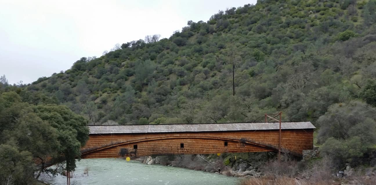
Bridgeport is located just about 5 miles north of Lake Wildwood and there is a great little State Park at the Historic World's Longest Wooden Bridge.  The Bridgeport Covered Bridge is located in Bridgeport, Nevada County, California, southwest of French Corral and north of Lake Wildwood. It is used as a pedestrian crossing over the South Yuba River. The bridge was built in 1862 by David John Wood. Its lumber came from Plum Valley in Sierra County, California. The bridge was closed to vehicular traffic in 1972 and pedestrian traffic in 2011 due to deferred maintenance and "structural problems. The Bridgeport Covered Bridge is the longest clear span of any surviving covered bridge in the world. It is 210 feet long.


These were the tolls of the day to cross the wooden bridge at Bridgeport, California back in 1862. That is cheap for sheep!!!


Englebright Reservoir - Nevada County, California


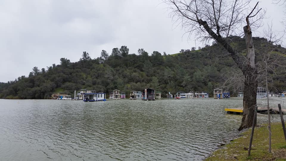
Visited on 3/9/2019, Jeff and I loaded up our dogs, Summer and Skye for a day adventure one hour north of our Ranch up to Nevada County, California.  This was a scattered rainy cloudy day, so we didn’t expect much, but just wanted to get out of the house and explore the South Yuba River area of Northern California.   We visited four lakes, two actually located in Nevada County and two in Placer County.  Englebright Reservoir was our first stop.  Lake Englebright (Englebright Reservoir) is at an elevation of 527 feet and is located off of Hwy 20 just west of Penn Valley, California.  The lake has a surface area of 815 acres with a shoreline of 24 miles that snakes 9 miles long above the dam.   The dam was built by the U.S. Army Corp of Engineers in 1941 in the steep Yuba River gorge known as the Narrows and was constructed for the storage of hydraulic gold mining debris.  Englebright Dam is a concrete arch structure which spans 1,142 feet across and is 260 feet high.  Jeff and I were first amazed by the amount of houseboats we noticed anchored in the marina area.  Then secondly we realized that none of these houseboats were of the late model variety, all of them are aging!  No two houseboats were the same and many of them were two stories tall, they had been modified and homemade or some would say….custom!  

Lake Englebright is unique and a boat camper's bonanza with only boat-in camping allowed along the 24 mile shoreline.  They have a total of 18 campgrounds and 100 campsites available for use.  We visited the boat launch area near the dam and Park Headquarters, and then on around to Skipper’s Cove, where there is a Marina store and houseboats can also be rented.   The shoreline is steep and rocky with a private rural feel to it.  Most of the scenery is of grassy rolling hills dotted with pines and oaks.  Fishing and house boating appears to be the favorite pastime on this lake’s quiet narrow coves.  Reading one of the signs stated that waterskiing is allowed only on the first 2/3 of the lake from the dam.  On the day we visited the lake was at full capacity of 538 feet above sea level and the dam was cascading with a roar of the excess water. 


San Antonio Reservoir - Alameda County, California


Visited on 3/10/2019, Jeff and I took a drive with our pups, Summer and Skye to the San Francisco Bay Area to take a tour of all of the lakes in Contra Costa County and a couple in Alameda County.  Our fourth Lake we visited in the Bay Area was San Antonio Reservoir.  San Antonio Reservoir is located in Alameda County, California, about three miles east-southeast of Sunol.  It was built in 1964 by the City and County of San Francisco. Formed by the James H. Turner Dam across San Antonio Creek not far above where it flows into Alameda Creek, its purpose is to store water from the Hetch Hetchy Aqueduct and local wells and watersheds. It has a surface size of 825 surface acres and is at an elevation of 463 feet above sea level.  Public access is considered trespassing, so we didn’t risk it and this is a stock photo.  

San Antonio Reservoir is located to the East of Fremont about 5 miles and north of San Jose.