Saturday, June 15, 2019

Lake Webb - Kern County, California


Jeff and I took a nice trip to Southern California for a Rodeo weekend in Banning, California outside of Palm Springs for the weekend.  We were camping with our two chocolate Labradors, Summer and Skye.  While on our camping adventure we set out to several lakes and reservoirs over the long weekend.


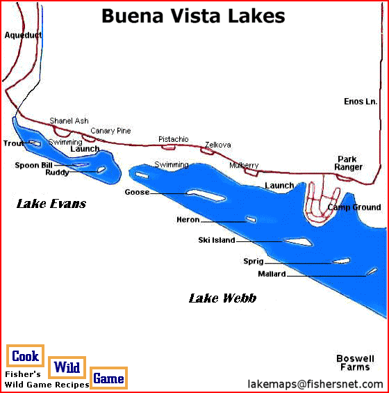
I visited Lake Webb on my way down to meet Jeff for camping at Lake Isabellar on my way down on 05/02/2019.   Lake Webb is an 873 acre manmade recreational lake located approximately 25 miles southwest of Bakersfield in the lower central valley of California.  It along with Lake Evans is one of two lakes that are part of the Buena Vista Aquatic Recreation Area southwest of Bakersfield.  At an elevation of 350 feet above sea level this lake was built in 1973.  It is primarily a motorboat, jet skiing, and waterskiing lake. The lake is located on the lakebed of the former Buena Vista Lake.  When the site was completed in April 1973, it took 43 days to fill both Lake Evans and the much larger Lake Webb with over 2,300,000,000 gallons (or 6,800 acre feet) of water.

Lake Webb is an elongated shape of 873 acres available for boating, jet‐skiing and fishing, as well as an additional 125 acres for jet‐skiing (maximum speed 45 mph). Projecting midway into the lake, a horseshoe‐shaped spit of land contains 112 campsites in a double row. To maintain the landscaping through the dry season, a sprinkler system operates, requiring campers to place their things in designated spots.


Lots of Oil Wells are out in the fields around Lake Webb and Lake Evans in the Bakersfield area.  This is one of the oil rigs in action.

Lake Evans - Kern County, California


Jeff and I took a nice trip to Southern California for a Rodeo weekend in Banning, California outside of Palm Springs for the weekend.  We were camping with our two chocolate Labradors, Summer and Skye.  While on our camping adventure we set out to several lakes and reservoirs over the long weekend.

I visited Lake Evans on my way down to meet Jeff for camping at Lake Isabellar on my way down on 05/02/2019.  Lake Evans is an 86 acre lake which is a manmade recreational lake located approximately 25 miles southwest of Bakersfield in the lower central valley of California.  It along with Lake Webb is one of two lakes that are part of the Buena Vista Aquatic Recreation Area.  Lake Webb and Lake Evans better known as "Buena Vista Lakes" are located in a flat basin which was once on the lakebed of the former Buena Vista Lake an elevation of 350 feet above sea level.   Projecting midway into the Lake Webb next door is a horseshoe‐shaped spit of land contains 112 campsites in a double row. This lake is the place for the more serene pursuits of sailing, fishing, and boating at no more than 5 mph.

Lake Webb and Lake Evans better known as "Buena Vista Lakes" are located in a flat basin, twelve miles northeast of the town of Taft and twenty-three miles southwest of the city of Bakersfield, at an elevation of 350’. The lakes are surrounded by a low bushes and small trees. On beyond that lies a huge flat dirt basin. One outstanding feature of Buena Vista Lakes is the extremely well maintained grassy picnic grounds along the northern side of the lakes.


Thursday, June 13, 2019

Hernandez Reservoir - San Benito County, California


Jeff and I took a nice trip to Southern California for a Rodeo weekend in Banning, California outside of Palm Springs for the weekend.  We were camping with our two chocolate Labradors, Summer and Skye.  While on our camping adventure we set out to several lakes and reservoirs over the long weekend. 

I visited Hernandez Reservoir on my way home on 05/06/2019.  Hernandez Reservoir is a 590 acre artificial lake located at an elevation of 2.411 feet above sea level created by impounding water from the San Benito River in the Diablo Mountain Range.  Located in Central California,100 southeast of San Jose, California.  The Hernandez earthen filled dam was built in 1962 on the San Benito River to control water supply down to the communities near Hollister, CA.


San Justo Reservoir - San Benito County, California


Jeff and I took a nice trip to Southern California for a Rodeo weekend in Banning, California outside of Palm Springs for the weekend.  We were camping with our two chocolate Labradors, Summer and Skye.  While on our camping adventure we set out to several lakes and reservoirs over the long weekend. 

I visited San Justo Reservoir on my way home on 05/06/2019.  San Justo Reservoir is a 202 acre reservoir at an elevation of 407 feet above sea level about three miles southwest of Hollister. The dam provides off stream water storage for the federal Central Valley Project via the Pacheco Conduit and Hollister Conduit fed by the San Luis Reservoir.

Completed in January 1986, the dam is an earthfill structure 151 feet high. Along with a companion dike structure 79 feet high, it forms a reservoir with a capacity of about 9,785 acre-feet.

Unfortunately, San Justo Reservoir was closed in 2008, following a Zebra Mussle infection and remains closed until further notice.  Zebra mussels have turned up in San Justo Reservoir causing authorities to close the reservoir to private boats. The discovery spurred the Department of Fish and Game to dispatch divers to 10 South Bay reservoirs to see if the mussel is infesting new territory.

The mussel, about the size of a dime, clumps together in large colonies that can block reservoir valves and clog water pipes as surely as plaque in the aorta.  This Reservoir is still closed after all these years however I was able to speak to one of the Drinking Water certified operators and he was nice enough to allow me in to the dam to take a few pictures.


Indian Valley Reservoir - Lake County, California


Campsite #2 at the Campground located at the South end of the Lake.


Jeff and I decided to load up the dogs on 5/26/2019 and take a Sunday fun day drive to Indian Valley Reservoir.  This 4,000 surface acre man-made lake in the mountain terrain 27 miles west of Williams, California and 15 miles east of Clear Lake just north near State Route 20.  The reservoir is located at an elevation of 1,421 feet above sea level.  We enjoyed throwing the ball into the lake for the dogs and spent a good hour just enjoying campsite #2 for the afternoon.

The reservoir was created by the construction of the Indian Valley Dam across the north fork of Cache Creek in 1975. The 965 foot long and 201 foot high earth-fill dam was built for water storage, irrigation and flood control.  Although the reservoir is in Lake County, it was built by neighboring Yolo County, who own all water rights to the 300,600 acre feet of water. The dam includes a hydroelectric plant.

The reservoir is in the Bureau of Land Management's Walker Ridge Recreation Area. All types of recreation are allowed, including boating, camping, fishing, hunting, hiking, bicycling and horseback riding.

There are two primitive boat/hike-in campgrounds, Blue Oaks and Kowalski. The best camping site is located at the furthest east end of the Kowalski campground with two picnic tables a couple of shade trees and your own access ramp area to enjoy the lake.

The area's flora and fauna include manzanita, oak and pine trees, blacktail deer, black bear, and wild turkey. Rare plants such as the Indian Valley Brodiaea and Adobe lily grow here.


Tuesday, June 11, 2019

Cunningham Lake - Santa Clara County, California


Visited on 3/31/2019 on a weekend camping trip to the South Bay Area where we camped at Coyote Lake in the foothills of Gilroy, California.  Lake Cunningham is an artificial lake in Lake Cunningham Park, in East San Jose, California, near the Eastridge Mall and Eastridge Transit Center.  It is located on Capitol Expressway and stands next to Reid-Hillview Airport. The Lake Cunningham Skate Park and Raging Waters theme park are also in Lake Cunningham Park.  This 55 acre lake is at an elevation of 10 feet above sea level.


The Lake Cunningham – Eastridge Mall area was one of Santa Clara Valley's three permanent wetland complex called "lagunas". The area was called Laguna Secayre during the initial Euro-American settlement (1769–1850). Laguna Secayre covered a much larger area than Lake Cunningham Park does now.

Due to intense urbanization in the surrounding hill areas, the storm water that historically exited the canyons and percolated through the gravel below ground was channeled into pipes below the streets to Thompson Creek and Lake Cunningham. This has led to an increase in runoff during the winter storms.

The lake and park are named after James F. Cunningham who owned the land before the city acquired it for flooding control.


Sunday, May 26, 2019

Calaveras Reservoir - Santa Clara & Alameda Counties, California


Jeff and I and our two chocolate Labradors, Summer and Skye camped at Coyote Lake in the hills east of Gilroy for the weekend.  While on our camping adventure we set out to several lakes and reservoirs over the weekend.  On Sunday morning we visited Calaveras Reservoir located in the hills 5 miles east of San Jose.  This 1,503 acre reservoir is located at an elevation of 781 feet above sea level.  Calaveras Reservoir is located primarily in Santa Clara County, California, with a small portion and its dam in Alameda County, California. In Spanish, Calaveras means "skulls".

The reservoir is fed mainly by Arroyo Hondo and Calaveras Creek. Lying in the Calaveras Valley, the region is geologically active with the Calaveras Fault parallel to and to the west of the dam site. The seismic hazard forced replacement of the original dam. The replacement dam began construction in 2011, with completion expected in 2019.

The Calaveras Valley has diverse wildlife including deer, coyotes, squirrels, turkey vultures, red-winged blackbirds, yellow-billed magpies, red-tailed hawks, brewer's blackbirds, purple martins, barn swallows, bullock's orioles, and warblers. Since at least 2008, a pair of bald eagles has nested regularly.

The dam site has an active earthquake fault nearby, and the original 1925 dam was seismically vulnerable.  If the dam had collapsed when full, it would have flooded part of Fremont, California with a wall of water 30 feet high.  Dam regulators for the state of California restricted the capacity of the original dam in 2001, to mitigate the seismic threat.  To restore lost capacity, the San Francisco Public Utilities Commission is constructing a replacement dam located 1,000 feet downstream from the original 1925 dam.

The design of the replacement dam allows for future capacity expansion, and the core is wider than needed initially.  The design allows the height to be raised by 150 feet, to quadruple the initial capacity of 100,000 acre feet of storage capacity.

In the 19th century, the Calaveras Valley which the reservoir now fills was primarily an agricultural region known for its production of hay, strawberries, and tomatoes. Because of San Francisco's increasing demand for drinking water at the turn of the 20th century, the farmers in the region were forced to sell their land to the Spring Valley Water Company, which in turn sold it to the San Francisco Water Company.

The first dam on the site, built in 1913 by the Spring Valley Water Company, rapidly changed the sensitive hydrology and natural environment of the Calaveras Valley. That dam suffered a collapse of the upstream slope in 1918 due to design and material flaws. Its replacement, the current Calaveras Dam, was the largest earth-fill dam in the world when it was completed in 1925. It is 245 feet high, with a length of 1200 feet at its crest. The city and county of San Francisco owns and operates the dam and reservoir for municipal water supply.

In the late 1980s and early 1990s, a drought affected California, and water levels in reservoirs throughout the state became extraordinarily low. By January 1991, the water at the reservoir was down 100 feet, and the aluminum body of an airplane became visible. Two skeletons were found at the site on January 5, 1991. Dental records and the plane's serial number were used to positively identify the remains as Clifford Gillman and his single-engine Ercoupe, along with Gillman's friend Robert Louviere. They had been missing since June 16, 1963. The wreck, minus the two men's remains, is still lying in the center of the reservoir.