Tuesday, July 24, 2018

Dark Lake - El Dorado County, California


Visited on 7/22/2018, Jeff and I loaded up our two chocolate Labradors, Summer and Skye and we traveled in the foothills of the Sierra Nevada in El Dorado County to visit a couple lakes on a summer day.  Our second stop was Dark Lake located near Wrights Lake which is east of Pollock Pines, California at an elevation of 7,000 feet above sea level.  It was a very smoky day due to the nearby Yosemite wildfires about two hours south of the lake.  Dark Lake is 22 miles from Highway 50 via the best roads. A shorter, 8-mile route is possible on Wrights Lake Road (Forest Road 4), but it has many tight turns not recommended for trailers or long vehicles.  This 30-acre lake is in the Sierra Nevada mountain range, west of Lake Tahoe on the western border of the Desolation Wilderness. It can be reached via Wrights Road off Ice House Road. It provides hiking access to the western portions of the Desolation Wilderness via the Twin Lakes trailhead. Wrights Road is not plowed and is inaccessible during the winter.


Wrights Lake - El Dorado County, California


Visited on 7/21/2018, Jeff and I loaded up our two chocolate Labradors, Summer and Skye and we traveled in the foothills of the Sierra Nevada in El Dorado County to visit a couple lakes on a summer day.  Our first stop was Wrights Lake located east of Pollock Pines, California at an elevation of 7,000 feet above sea level.  It was a very smoky day due to the nearby Yosemite wildfires about two hours south of the lake. 

Wrights Lake is 22 miles from Highway 50 via the best roads. A shorter, 8-mile route is possible on Wrights Lake Road (Forest Road 4), but it has many tight turns not recommended for trailers or long vehicles.  The 45-acre lake is less than a mile long. Cabins line the northern and eastern shores. This small lake is in the Sierra Nevada mountain range, west of Lake Tahoe on the western border of the Desolation Wilderness. It can be reached via Wrights Road off Ice House Road. It provides hiking access to the western portions of the Desolation Wilderness via the Twin Lakes trailhead. Wrights Road is not plowed and is inaccessible during the winter.


Saturday, July 14, 2018

New Melones Lake - Calavares & Tuolume Counties


Visited 8/18/2012, Jeff and I went boating with our boat on New Melones Lake a couple of years ago.  New Melones is a reservoir on the Stanislaus River in the central Sierra Nevada foothills, the New Melones Dam and reservoir are a water collection and transfer unit of the Central Valley Project. New Melones Lake provides irrigation water, hydroelectric power, flood control, and wildlife habitat. Recreation uses include fishing, camping, and boating within the Glory Hole Recreation and Tuttletown Recreation Area.

The reservoir is impounded by the New Melones Dam, and is the fourth largest reservoir in the State of California at 12,500 acres.  When full, the shoreline is more than 100 miles long.
The reservoir and dam are located west of Jamestown and Sonora, and south of Angels Camp. The Archie Stevenot Bridge, completed in 1976, carries Hwy 49 across the lake and border between Calaveras and Tuolumne Counties.  At an elevation of 1,088 feet above sea level, New Melones Lake is part of Reclamation’s Central Valley Project. It is located off of Highway 49, some 8 miles north of Sonora and 6 miles south of Angels Camp, in the Mother Lode.  Each year, approximately 600,000 visitors enjoy New Melones’ numerous recreational opportunities. Facilities include day use areas; boat launch ramps; more than 300 campsites; hiking, biking and equestrian trails; a visitor center and museum; and abundant water-based recreation.  New Melones Dam is an earth and rock filled embankment dam on the Stanislaus River, about 5 miles (8.0 km) west of Jamestown, California in the United States, on the border of Calaveras County and Tuolumne County. The water impounded by the 625-foot tall dam and is in the foothills of the Sierra Nevada east of the San Joaquin Valley. The dam serves mainly for irrigation water supply, and also provides hydropower generation, flood control and recreation benefits.
The dam was authorized in 1944 as a unit of the federal Central Valley Project, a system designed to provide irrigation water to the fertile agricultural region of the Central Valley. It would be built by the U.S. Army Corps of Engineers (Corps), and transferred to the U.S. Bureau of Reclamation (Reclamation) upon completion. In 1966, work began to clear the foundations for a high dam that would replace an earlier, much smaller structure built by two irrigation districts. Construction of the main embankment began in 1976, and was topped out in late 1978. Water storage in New Melones Lake commenced in 1978, and the dam's hydroelectric station produced its first power in mid-1979.

New Melones was the focus of a long environmental battle during the 1970s and early 1980s; critics protested the flooding of a long scenic stretch of the Stanislaus River, which flowed over whitewater rapids through the deepest limestone canyon in the western United States. The protestors employed a variety of methods, some extreme, to prevent the filling of New Melones Lake until 1983, when record-setting floods filled the reservoir and nearly breached the dam's emergency spillway. The fight over New Melones galvanized the river conservation movement in California and influenced major water policy changes on the state and federal levels; since its completion, no other dams of its size or importance have been built in the United States.


Picture taken on our boat on New Melones Lake in August 2012 with our old girls, Star on the left and Sadie on the right.  We sure miss those pups...


Thursday, July 12, 2018

Canyon Lake - Riverside County, California


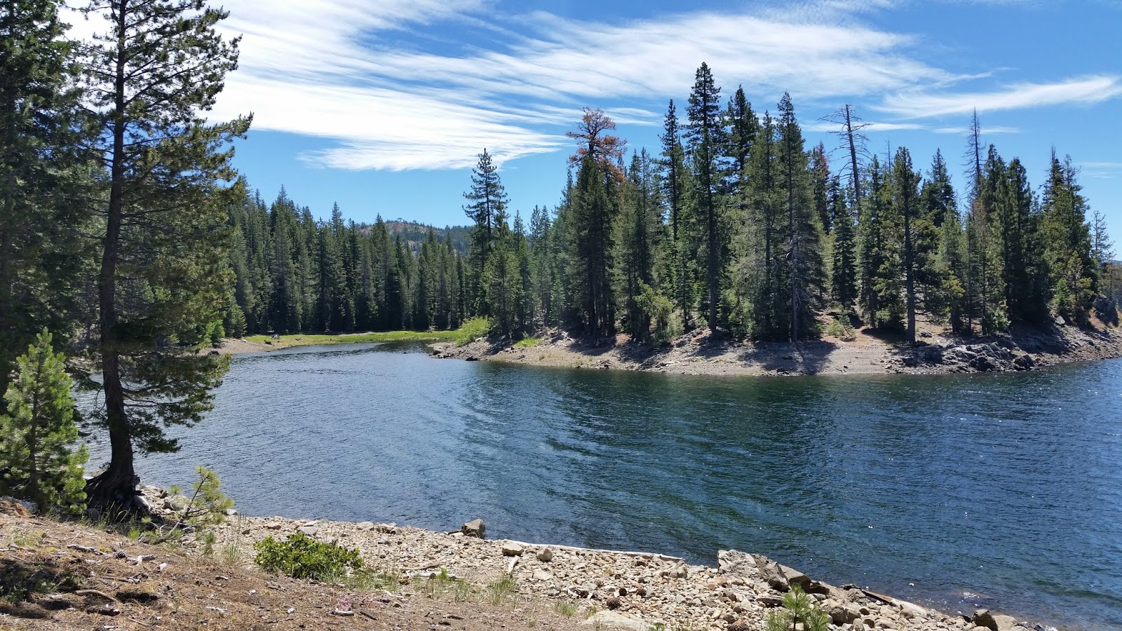
Canyon Lake reservoir, a 525 acre lake located in western Riverside County is a gated community east of Lake Elsinore and Interstate 15 in the southern foothills of the Temescal Mountains.  At an elevation of 1,384 feet above sea level, Canyon Lake began as a master-planned community developed by Corona Land Company in 1968. The “City of Canyon Lake” was incorporated on December 1, 1990. Railroad Canyon Dam was built in 1927, and impounds the San Jacinto River to fill the reservoir, which covers 383 acres and has 14.9 miles of shoreline

Canyon Lake is located east of Lake Elsinore and Interstate 15, in the southern foothills of the Temescal Mountains. The mountain range is on the western edge of the Perris Block and east of the Elsinore Fault Zone.  The community is named for Canyon Lake reservoir, also known as the Railroad Canyon Reservoir, which it surrounds. The reservoir, created in 1928 with the construction of the Railroad Canyon Dam, covers approximately 525 acres (212 ha), has 14.9 miles of shoreline.  It is owned and operated by the Elsinore Valley Municipal Water District.
The reservoir is supplied by storm water runoff from the San Jacinto River and Salt Creek. Water from the reservoir feeds the Canyon Lake Water Treatment Plant, which provides approximately 10% of the domestic water supply in the Lake Elsinore/Canyon Lake area.

In 1882 the California Southern Railroad built a line from Perris to Elsinore along the east side of the San Jacinto River. The Santa Fe Railroad bought the line and joined it with their line in San Bernardino. Floods in 1884, 1916, and 1927 washed out the tracks, and the Santa Fe Railroad decided to abandon the line. Soon after the last flood the Temescal Water Company bought the railroad right-of-way, as well as 1,000 acres (400 ha) from Henry Evans, a rancher, and other land from B.T. Kuert. Those were the two parcels that make up most of Canyon Lake today. 
Construction started in 1927 to build a dam across the river to store water. It was finished in 1929. Railroad Canyon Reservoir, when built, was one of the largest fresh water lakes for fishing, hunting and camping in Southern California.

Faucherie Lake - Nevada County, California


Visited on 7/7/18 during a long weekend trip to Lake Tahoe to watch the 4th of July Fireworks Celebration and for a long weekend of High Sierra camping with Jeff and our dogs, Summer and Skye.  We centrally located ourselves for the weekend at the Lodgepole campground at Lake Valley Reservoir near Cisco Grove, CA. Faucherie Lake is a amazing and beautiful 144 acre lake situated at the base of rocky cliffs, which can be viewed from the campground. Large boulders are strewn throughout the area. Some consider Faucherie to be the prettiest lake in the Sierras.  At an elevation of 6,132 feet above sea level popular water sports such as canoeing, kayaking and trout fishing are popular activities on Faucherie Lake. Hiking trails crisscross the surrounding area, including one to the 18-foot Faucherie Lake Falls.

The campground offers two groups sites, each of which can accommodate up to 25 people. Sites are equipped with picnic tables and campfire rings. Vault toilets and trash collection are provided.  I would strongly recommend an off-road 4 wheel drive vehicle to access this lake.  We made it there and back in our Jeep Wrangler with highway tires, but unfortunately we had a flat tire on our way out.  The sharp rocks on the roads to this lake can cause damage to highway tires.  Very hard to access, but totally worth the viewing and experiencing this beautiful place.  This is one of my favorite lakes!


Sawmill Lake - Nevada County, California


Visited on 7/5/18 during a long weekend trip to Lake Tahoe to watch the 4th of July Fireworks Celebration and for a long weekend of High Sierra camping with Jeff and our dogs, Summer and Skye.  We centrally located ourselves for the weekend at the Lodgepole campground at Lake Valley Reservoir near Cisco Grove, CA.  Sawmill Lake is a 114 acre lake that is at an elevation of 5,800 feet above sea level.  The beautiful Canyon Creek connects Lake Faucherie, Sawmill Lake and Bowman Reservoir in the Sierra, Tahoe National Forest. 20+ miles of backroad travel, off I-80.

While many consider Faucherie Lake to be the most beautiful scenic lake, Sawmill Lake just downstream a couple of miles is still quite attractive – with dense forests and a granite mountain backdrop. Sawmill is especially nice for those who like to primitive camp, outside of developed campgrounds. Way off the interstate @ Hwy 20, tucked in way back behind Bowman Lake a few miles, you can find Sawmill Lake.

Fishing and camping, kayaking and canoeing are all popular recreation around this lake. A trailhead on the north end of the lake leads out to even more alpine lakes (a day hike “lake loop” or backpacking option). The Pacific Crest Trail is also routed nearby.  No motorized boats or watercraft allowed. No boat ramps, no pavement, no picnic tables, no bathrooms, no fees.
The north shoreline is abundant with dispersed campsites: metal fire rings and a clearing only; no picnic tables, no toilets. Self sufficient campers only. Campfire permits, a water bucket and a shovel are required. During extreme fire restrictions campfires may not be allowed. Check with local rangers for up to date info.  Most campsites are drive up and park, while others closer to the shoreline have only walk-in access. Hauling your gear down hill won’t seem unthinkable once you’ve seen the lakeside views. There is even a camp below the dam, next to the waterfall.

The main access Road #843-037 is very rocky and 4x4s love to frequent the area. The backroads here are best suite for truck travel, high clearance vehicles, off-roaders and SUVs. No small RVs or trailers. Passenger cars are not recommended. The access roads around the lake and up to the lake are dusty and rugged. The road below the dam is quite rough w/ rocks.  We ended up with a flat tire due to the extreme jagged rocks on the roads.


Jackson Meadows Reservoir - Nevada County, California


Visited on 7/7/18 during a long weekend trip to Lake Tahoe to watch the 4th of July Fireworks Celebration and for a long weekend of High Sierra camping with Jeff and our dogs, Summer and Skye.  We centrally located ourselves for the weekend at the Lodgepole campground at Lake Valley Reservoir near Cisco Grove, CA.  Jackson Meadows Reservoir is a 1,028 acre lake at an elevation of 6,040 that is totally amazing.  We stopped and found a great spot on the north side of the lake for a lunch break from the back of the Jeep Wrangler and Jeff took a swim with the dogs.  Several nice campgrounds are located around this lake including a nice horse camp with corrals located just feet from the Pacific Crest Trail.


Lunch from the back of the Jeep on the north side of the lake.


Jeff taking a swim in the nice crystal blue waters of Jackson Meadows Reservoir.

Wednesday, July 11, 2018

Webber Lake - Sierra County, California


Visited on 7/7/18 during a long weekend trip to Lake Tahoe to watch the 4th of July Fireworks Celebration and for a long weekend of High Sierra camping with Jeff and our dogs, Summer and Skye.  We centrally located ourselves for the weekend at the Lodgepole campground at Lake Valley Reservoir near Cisco Grove, CA.  Located at an elevation of 6,795 feet above sea level, Webber Lake, a 215-acre natural lake at the  headwaters of the Little Truckee River, has been a private fishing campground since the 1860s. It  was stocked with trout back then, one of the earliest known examples of sport fishing in the Sierra Nevada. 
Henness Pass Road, once one of the most heavily traveled emigrant routes across the Sierra Nevada, runs past the lake. The Webber Lake Hotel, built in 1860, still stands on the property, the only remaining stagecoach hotel along the historic route.            

The California Department of Fish and Game says the property provides critical habitat for a  number of animals protected by state law, including the pine marten and the Sierra Nevada red  fox. Other animals recorded on the property include black bear, mule deer, mountain lion, bald  eagle, raptors, and the endangered willow flycatcher. The wildflower displays in Lacey  Meadows are among the best in the Sierra and include lupine, larkspur, elephant heads, alpine buttercups, monkshood, and leopard lilies.

The Truckee Donner Land Trust will own and manage the property. Its near-term plans include  new trailheads along Henness Pass Road and Meadow Lake Road, providing non-motorized access to Lacey Meadows. At the request of the Johnson family, the Land Trust will continue to lease the fishing campground to the current caretakers for four more years, after which the lake will be open to the public.


Pictures taken from the campground located on the northside of the Lake.

Independence Lake - Nevada County, California


Visited on 7/5/18 during a long weekend trip to Lake Tahoe to watch the 4 th of July Fireworks Celebration and for a long weekend of High Sierra camping with Jeff and our dogs, Summer and Skye.  We centrally located ourselves for the weekend at the Lodgepole campground at Lake Valley Reservoir near Cisco Grove, CA. Independence Lake is 800 acres large at an elevation of 6,949 feet above sea level. 

Independence Lake is one of the most pristine alpine lakes west of the Rockies. For 50 years, Independence Lake has been the target for development, with the threat of permanent closure. Over the decades, the Disney Corporation and a Silicon Valley billionaire have tried to purchase the land and lake for profit-making endeavors. Protection efforts have been ongoing due to the lake being the home of the last wild populations of Lahontan cutthroat trout. The Nature Conservancy and Land Trust have secured the area now, with plans to construct user-friendly trails and campgrounds.

The lake and surrounding alpine forests offer exceptional recreation, including hiking, fishing, kayaking and bird watching in the beautiful Sierra Nevada.  Independence Lake's beauty and rustic nature are matched only by the amazing biodiversity that it supports. Independence Lake is home to one of only two wild, self-sustaining lake populations of Lahontan cutthroat trout in the world - a fish that has been lost from 99% of its historic range. Independence Lake also plays an important role in providing clean drinking water to western Nevada by acting as storage for water needed during drought.

In addition to the Lahontan cutthroat trout, Independence Lake hosts populations of six other native Lahontan fishes that have lived here since glaciers disappeared some 10,000 years ago. Because of its pristine nature and intact ecosystem, Independence Lake has become a unique refuge for rare fish.

The surrounding pine forest is home to black bear, mountain lion, and mule deer. Bald eagles and osprey can be seen from the shorelines, hunting fish. A wolverine has also been spotted near the lake. The region is also home to rare species like the willow flycatcher, mountain yellow-legged frog and Sierra Nevada mountain beaver.

Independence Lake also plays an important role in supporting human communities. As a part of the Truckee River watershed, the lake is a crucial part of the system that supplies clean drinking water to northern Nevada, including Reno and Sparks–particularly during drought.


Cascade Lake - El Dorado County, California


Visited on 7/4/18 during a long weekend trip to the Lake Tahoe area to watch the 4th of July Fireworks Celebration and for a long weekend of High Sierra camping with Jeff and our dogs, Summer and Skye.  We camped at the D.L. Bliss State Park campground just north of the Emerald Bay area on the west side of Lake Tahoe.  Then we moved the next day and centrally located ourselves for the weekend at the Lodgepole campground at Lake Valley Reservoir near Cisco Grove, CA.  Cascade Lake is located just north of Fallen Leaf Lake on the  southwest corner of Lake Tahoe.  The lake is located at 6,453 feet above sea level. 

Martis Creek Lake - Nevada County, California


Visited on 7/5/18 during a long weekend trip to Lake Tahoe to watch the 4th of July Fireworks Celebration and for a long weekend of High Sierra camping with Jeff and our dogs, Summer and Skye.  We centrally located ourselves for the weekend at the Lodgepole campground at Lake Valley Reservoir near Cisco Grove, CA. Martis Creek Lake is located on the northeast side of Truckee, CA at an elevation of 5,823 feet above sea level.  The Lake is 768 acres and is only 12 miles from the world-famous Lake Tahoe. Known for its outstanding catch-and-release trout fishing, this is a great site to set up camp, go for a hike, mountain bike, picnic, or enjoy a paddle. Martis Creek Lake, nestled in the Sierra Nevada near Lake Tahoe, was created upon the completion of Martis Creek Dam in 1972. The dam, 113 feet high and 2,670 feet long, holds back a lake with a capacity of 20,400 acre feet of water. When full, its surface covers 768 acres. The lake is normally maintained at minimum pool covering 70 acres. The dam and lake provide flood protection for the surrounding area. The lake, operated by the U.S. Army Corps of Engineers, also provides a focal point for a host of recreation activities. Their scenic campground has quiet, shaded, well spaced campsites and is close to the large variety of activities offered by the Lake Tahoe-Truckee area during the summer.


Weaver Lake - Nevada County, California


Visited on 7/5/18 during a long weekend trip to Lake Tahoe to watch the 4th of July Fireworks Celebration and for a long weekend of High Sierra camping with Jeff and our dogs, Summer and Skye.  We centrally located ourselves for the weekend at the Lodgepole campground at Lake Valley Reservoir near Cisco Grove, CA.  This small 85 acre lake is at an elevation of 5,755 feet above sea level.

Weaver Lake is located just northwest of Bowman Lake.


McMurray Lake - Nevada County, California


Visited on 7/6/18 during a long weekend trip to Lake Tahoe to watch the 4th of July Fireworks Celebration and for a long weekend of High Sierra camping with Jeff and our dogs, Summer and Skye.  We centrally located ourselves for the weekend at the Lodgepole campground at Lake Valley Reservoir near Cisco Grove, CA.  McMurray Lake is a small 35 acre lake located at 5,837 feet above sea level.

McMurray Lake is located just northwest of Bowman Lake.

Lindsey Lake - Nevada County, California


Visited on 7/6/18 during a long weekend trip to Lake Tahoe to watch the 4th of July Fireworks Celebration and for a long weekend of High Sierra camping with Jeff and our dogs, Summer and Skye.  We centrally located ourselves for the weekend at the Lodgepole campground at Lake Valley Reservoir near Cisco Grove, CA. Lindsey Lakes consists of a row of three lakes which is the most western lake is Lower Lindsey Lake which is the largest of the three at 40 acres at an elevation 6,238 above sea level.  Located within the Tahoe National Forest Lower Lindsey Lake has a primitive campground, with 12 campsites, vault toilets, and no trash service.  Some great hiking in the area, fishing and swimming.  The lakes are flanked with conifers and deciduous trees that shimmer a lighter green hue.  In spring till early summer the open meadows surounding the lake are filled with wildflowers.


Bowman Lake - Nevada County, Calfiornia


Visited on 7/6/18 during a long weekend trip to Lake Tahoe to watch the 4th of July Fireworks Celebration and for a long weekend of High Sierra camping with Jeff and our dogs, Summer and Skye.  We centrally located ourselves for the weekend at the Lodgepole campground at Lake Valley Reservoir near Cisco Grove, CA.  Bowman Lake is 825 acres large and is located at 5,561 feet above sea level.